
lütschetalsperre - a water dam near frankenhain.
as the valleys below the 500 meter mark were getting greener and greener by the day, up in the mountains this usually takes a little while longer. such was also the case when i visited my parents briefly in thuringia and we made a day trip to the thuringian forest! our hike that day started out at the lütsche dam and would lead us deep through the woods, along old timber rafting channels with great views on the surrounding mountains! all in all, the hike was about 20 kilometer long, and let me tell you, i did notice every single bone and muscle at the end of that day 😂 it sure was quite a lovely hike, though, especially with the mountain spring showing its splendor! i adored all the budding greens and light & shadow moments on that very sunny day!

fresh goatwillow blossoms, they're female ones! did you know that willows are dioecious, which means that there are trees that only produce either male or female blossoms and you can only find that out by really looking close? the stigma of the female blossom is really unimposing, looking like brown little dots, whereas the male ones are yellow and smell honey-like! and why is it called goatwillow? because goat friends love to nibble on their juicy leaves ;)

the lütsche dam is supplied with the waters of the creek lütsche, hence its name. it has about 14 hectares of water surface, holds 1.07 million cubic meters of water and has an output of 14 kW.

the lütsche dam is actually a special one of all the thuringian forest dams, it's being used as a recreational body of water where you can swim in the summer and do all kinds of other activities like diving and water sports. the temperatures are fairly cold, though, the water rarely rises over 20 degree celsius.

the beach of the dam was actually quite inviting! i would sure love to hang around here in summer times and enjoy this beautiful place!


the steinige lütsche ( rocky lütsche ), one of two headstreams of the lütsche creek.
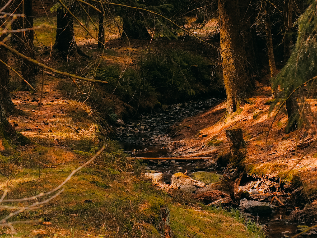 it sure was a very rocky little rivulet.

our path led us adjacent to a camping site into the valley of the grasige lütsche ( grassy lütsche ). passing by the more permanent camp spots we found this funny sign. the arrow on top says that we'll find a wet corner further down the path, it also tells us that we reached the spa resort of bad promille ( per mill spa ) in the district blackout. it also warns us to pass the boundary of this particular place.
clearly, a drinker's welcome sign 😂

the grassy lütsche was equally rocky, but in comparison to the rocky lütsche it was embedded into a more grassy environment ;P

i LOVED this area, it really felt so perfectly mountainous! listening to the bubbling of the little creek was absolutely comforting and therapeutic!


i love me some tiny mountain creeks 💚

seriously, this scenery encapsulates the thuringian forest atmosphere to me! creeks, rocks, lots of conifer trees and moist meadows!
 inbetween older trees, some new baby ones were planted.
upturned rootage.

the hiking paths were framed by lots of dark green firs and spruces, and as is custom in these woods, were at times quite steep! paths like this would later make my hip bones hurt 😂 they don't look dangerous, but the constant ascend would proof quite impactful on my body.

after a little while we came upon this little pond - the oberer sieglitzteich ( upper sieglitz pond ). it was once used as a water supply for the lütsche dam, but these days it doesn't hold that function anymore. now it's just an idyllic little pond deep in the woods where you can sit down and enjoy the sounds of the thuringian forest.


every so often we came upon these cute sign posts that boasted some local dialect dictums. some of those i really couldn't translate in my head, because i just did not understand! the people in the thuringian woods surely have a very special dialect that even i, as a born thuringian, cannot decipher it often 😂 i think this sound bite basically means that 'many heads mean a lot of minds, but too much talking never brings benefits'. so, even more simple, too many ideas and talking don't yield much profit. i wholeheartedly agree!

found a sweet, sweet wood sorrel blossom! you can actually eat these in tiny doses, they bring taste into salads, soups and dips! but don't overdo it, they can be toxic in copious doses.

a blue momma in a green forest 💙

my parents being utterly tired of life, scrambling on the edge of this abyss 🙈
nah, actually, it looks way more dangerous than it truly was. notice the sign post next to my dad? just shows that the hiking path continued there, even though it looks like it ended 😅

we had great views over the thuringian forest from here! i think, the rock we are standing on here was called 'hoher stein', but i am not super sure about that anymore, even though we encountered signposts telling us to go there.

such a typical thuringian forest view 😍 lots and lots of coniferous woodlands & many mountain peaks.

we were trodding quite some adventurous little pathways to get to places.

a nice picnic place where we stopped and actually ate some of the food we were bringing with us.

to get back on the path of the flössgraben ( a former timber rafting channel turned hiking path ), we had to climb down this seriously slippery slope - and yes, it was actually the only way down from where we had come from. we took each other by the hands and helped each other down bit by bit, all the while cursing about this unreasonable path 😂

we didn't really get grumpy for too long, though, because then we came upon the 'ausgebrannter stein' ( burnt out rock ) - which historically had been part of the timber rafting channel. it was built in a grueling fashion around 1700 - using extreme heat to crack the rocks, which is called fire-setting, a very ancient mining method. it was dangerous, toxic and hard labour for the men having to build this tunnel, which is 38 meters long. unfortunately the timber channel only was in use for 20 years, so all the hard work was basically for nothing. well, not entirely, since we tourists today can marvel at the craftmanship of our old ancestors and actually wander through the dark tunnel.

a pair of parents getting smarter by reading some historic facts about the tunnel ;P

entering the tunnel. it was not lit at all, and for the first few moments it was kind of spooky to enter it after the sun had been so bright in the woods before. i have to admit, i actually pulled out my phone and lit up the flashlight, there was really no light source coming in from the other side of the tunnel ( i think it went around a corner ).

reaching the other side of the tunnel, already indicating a wondrous and gorgeous view!

a view that i could not get enough of! how pretty is this sight? made up for all the spooky moments inside the tunnel ;P
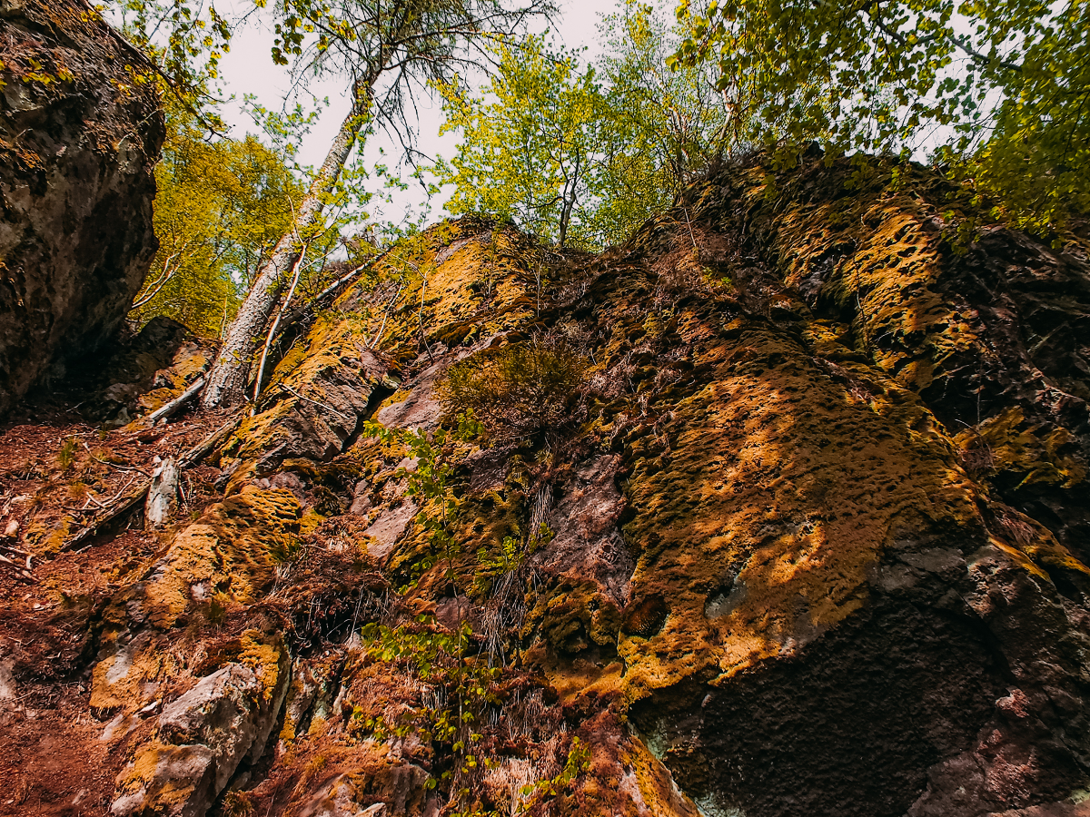
overgrown mossy and lichen-covered rocks behind us! the rocks around here were mainly porphyry rocks.

very impressively looming above our heads.

i might totally be wrong, but the mountain peaks seen here in the distance could be ( from left to approximately the middle where the trees reach up into the sky ): sachsenstein, brand, teufelskreis & schneekopf ( the highest of them all with 978 meters above see level ). i am fairly sure about the schneekopf peak, since it is the only one having a huge look-out tower, guaranteeing views from an over 1000 meter high level! can you spot the look-out tower?

how badass does my momma look here? super badass in my opinion 💪 i adore this picture of her so much! probably need to print it out and gift it to her at some point!

a peak onto a tiny bit of mountain street! i think it's the landesstraße 2615, which leads from schmücke to gehlberg to the connection point of the L2149 right near ausgebrannter stein. also somewhere down there should be the 'wilde gera' ( one of two feeders to the river gera ).

just the contrast of the dark green conifers to the budding neon green colours of deciduous trees is excellent already!

view towards the bettelmannskopf ( which is about 700 meters high ).

we decided to head back through the tunnel to continue a different path back to the lütsche dam.

the 'zwä zwillinger' ( two twins in the local dialect ) stop showing us where to go. we did come from the hoher stein look-out and sieglitzteich ponds, and would proceed towards gräfenroda & tragberghütte along the flößgraben path.
a little sign asks hikers if two twins now means 2 or 4? you decide ;P

this big road is actually an autobahn, to be exact it is the A71, which runs through a long tunnel underneath the mountain right below this view and will bring you to oberhof & zella-mehlis. that tunnels ( the rennsteigtunnel ) is actually germany's longest tunnel with almost 8 kilometers length!

the shot shows the view towards the wilde gera valley.

it is always a little strange to view moving things from a great height, watching the world go by like little ants moving about. i always get such an overwhelming sense of how all is incredibly fleeting and hard to grasp.

it is hard to say, but the bumpy mountain in the image center might be part of the arlesberg, maybe its western spur. there's more mountains visible far in the back, but its impossible for me to say what they are named. maybe the dörrberg & schiebigenberg near geschwenda? it will stay a mystery to me, because when looking at maps, my brain tells me that there should not be any mountains anymore, that the thuringian forest should end shortly after the arlesberg, but since there are curves and shiftings in the perspectives from which i have shot these images, it is definitely fucking up my sense of direction a bit 😂

goethe said: how fertile is the smallest circle, when you know how to care for it well!
&
the dialect part roughly translates into: only a rotten person pushes with his ass home what others created with their hands. now the meaning of that is open to interpretation 😂

overlooking a great valley on our way back to the dam. i think this was the sieglitzgrund, where the sieglitz river was running towards its confluence into the wild gera.

spruces and firs galore.

'this is the way home! but sometimes this one, too!'
just shows the queer and a little morbid humour thuringian forest citizens have sometimes.

the more the sun set, the better the atmosphere got!

beautiful sunlit forest paths - magic par excellence!

i mean, how can you not swoon seeing places like this?

after about 20 kilometers of hiking up and down hills and mountains we finally returned to the lütsche dam. by the time we were walking the last meters i couldn't walk properly anymore, limping slowly behind my parents ( they surprisingly held up well! ). not only did my hips hurt, but also my knee was affected, the one that i sometimes already have problems with ( it likes to dislocate sometimes if it is overly strained ). alas, i had to grit my teeth together and with endurance and a few photo taking breaks, i made it to the car happily, but exhausted.

the holidayhaus lütsche - a little hotel with 5 appartments directly on the shores of the dam lake!

they have a huge sun deck and apparently also provide a whirlpool for their guests. the place seems rather lovely, actually, i wouldn't mind spending a week-end here, hiking, going for a swim in the summers, or just plain getting cozy in the winters after a day out in the snow!

towards the retaining wall, on which you can cross over back to the other side of the dam lake.


the retaining wall is a gravity dam made out of concrete and is a little arched.

the view from the wall over the lake! pretty sweet, isn't it?

the flood relief side of the wall. it ends up in small basins ( there's another one not seen in this photo ).

i really would like to be witness to a discharge of the dam. is it going to flood the whole lütsche valley? or do they gradually let out the water so it doesn't flood everything? i know one thing for sure, though, that it must be exciting and strange at the same time to see the dam lake empty.

magical sun moment as a final photo of this lenghty post!
while i was totally tuckered out after this hike, i was still satiated with a wonderful thuringian forest experience, bathing in spring sunlight and that very special mountain atmosphere that only these woods can provide!
Comments